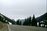
US 550 going north from Durango to Ouray in early May. Red Mountain pass. There was an installment of the comic strip "Calvin and Hobbes" in which the two made a particularly hairy sled ride. At the end, Calvin remarks: "I think that was our best ride ever." Hobbes responds: "I kept closing my eyes. Let's do it again." My feelings about Red Mountain pass were like those of Hobbes. But if I had to do it again, I would take 550 in the other direction, going south.
Personally, I already get nervous on an elevated highway. And Red Mountain pass is hardly reassuring. The most scary curves do not have any guard rails, probably not to obstruct the view for the tourists. Some steep curves slope downwards toward the outside of the curve. Maybe because of spring, but the road over the pass was full of gravel. The guide lines to tell you where the road ends and the shoulder begins were completely gone in many places. And with the gravel on it, I was at times lost about where I should be driving. Not reassuring for someone not eager to drop thousands of feets down a steep mountain edge. Nor is slipping around on gravel on a downwardly sloped curve.
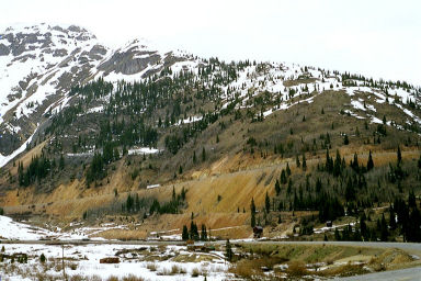
In fact, I was so upset after having gone over the pass that I did not spool my film back completely before opening my camera and lost some pictures, including all of CO 65. But at least I was back on relatively level and safe ground, near a tiny city called Silverton. I took some pictures looking back at the pass, and also one of a colorful redish mountain in front of me and shown above.
Taking this picture, I noticed with a sinking feeling that what appeared like a tiny truck was inching up a steeply inclined road along its side. A panicky look on the map confirmed that, yes, this disaster road has two passes, and I had gone over Coal Bank Hill pass. Red Mountain pass was still to come.
I was stuck between two passes, so there was not much choice. I can confirm that the road quality of Red Mountain pass is even worse than that of Coal Bank Hill pass. I know there were some waterfalls, because I heard them and felt some water splashing on me. But I did not want to take my eyes off the road. Somehow if I did, I ended up driving on the wrong lane.
Then there were some big sharp red stones lying in the middle of the road. I only saw them at the last moment due to a truck in front of me. It seemed to me that one stone was small enough to go over, and I was not eager to make wild last minute swerves thousands of feet up. Mistake. The stone hit the bottom of my car at several places. So I had to stop and check for damage. Fortunately, that piece of road was not too bad, with the mountain at my side of the road for a change and just enough room to park the car next to the road. The only damage proved to be a tear in the plastic splash guard below the engine.
Apparently the locals refer to 550 as the "Million Dollar Highway." This does not surprise me one bit, since to my knowledge a good quality highway would cost a hundred times that much. I have been told that Independence pass near Aspen is worse; I assume it is an ice-covered dirt track. I plan to stay clear. I had no particular difficulty with the other six or seven passes I encountered on my trip, though. In particular, in Colorado the Colorado state highways and US 50 seem to be well maintained.
|