Through the remainder of Missouri and a corner of Kansas to end up in Oklahoma. Spend some time finding superglue to fix a broken cover on my digital camera. The repair failed.
Then the map showed Route 66 tracks both above and below I 44. After a lot of thinking, I decided to take the northern track. Which dead-ended after a considerable amount of miles. What could I do? A Miata is not a SUV. I turned back and took the southern track. This looked like a much longer pencil sketch on the map. It was. It took much longer to dead-end. So I turned back again and took I 44. They were nice roads, though. Except of course I 44.
This part of Missouri does not give directions for Route 66. However, after you have found it, there is often a Route 66 sign confirming it. The best way to follow the road is: (a) At each intersection take every possible direction and follow it for a mile. (b) If you do not see a Route 66 sign, return to the intersection. (c) If none of the directions produces a Route 66 sign, take the most logical extension of the road you were going.
A lot of often quite heavy rain and thunderstorms today. I got caught driving in an heavy one top-down when it came up quicker than I expected. Fortunately, no stops needed to be made until I found a brief lull to put the top up. A no-zip top is nice. Aside from the rain, it was relatively cool compared to earlier days, and I had the top down whenever it was not raining. The roads were also again generally nice.
Near the end of the day, I spend much time searching for 93 octane gas. I tried about 10 gas stations and driving about 20 or 30 miles out of my way to the Interstate exits. 91 was highest. Every Conoco station adds injury to insult by offering 87, 88, 89, 90, and 91 octane. Gee, I am impressed with the choice in octane offered. Finally, a cheer for the Texaco station in Afton, OK, for having real 93 octane gas. Not even with ethanol.
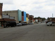
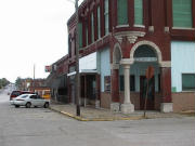
Pictures (click for larger size):